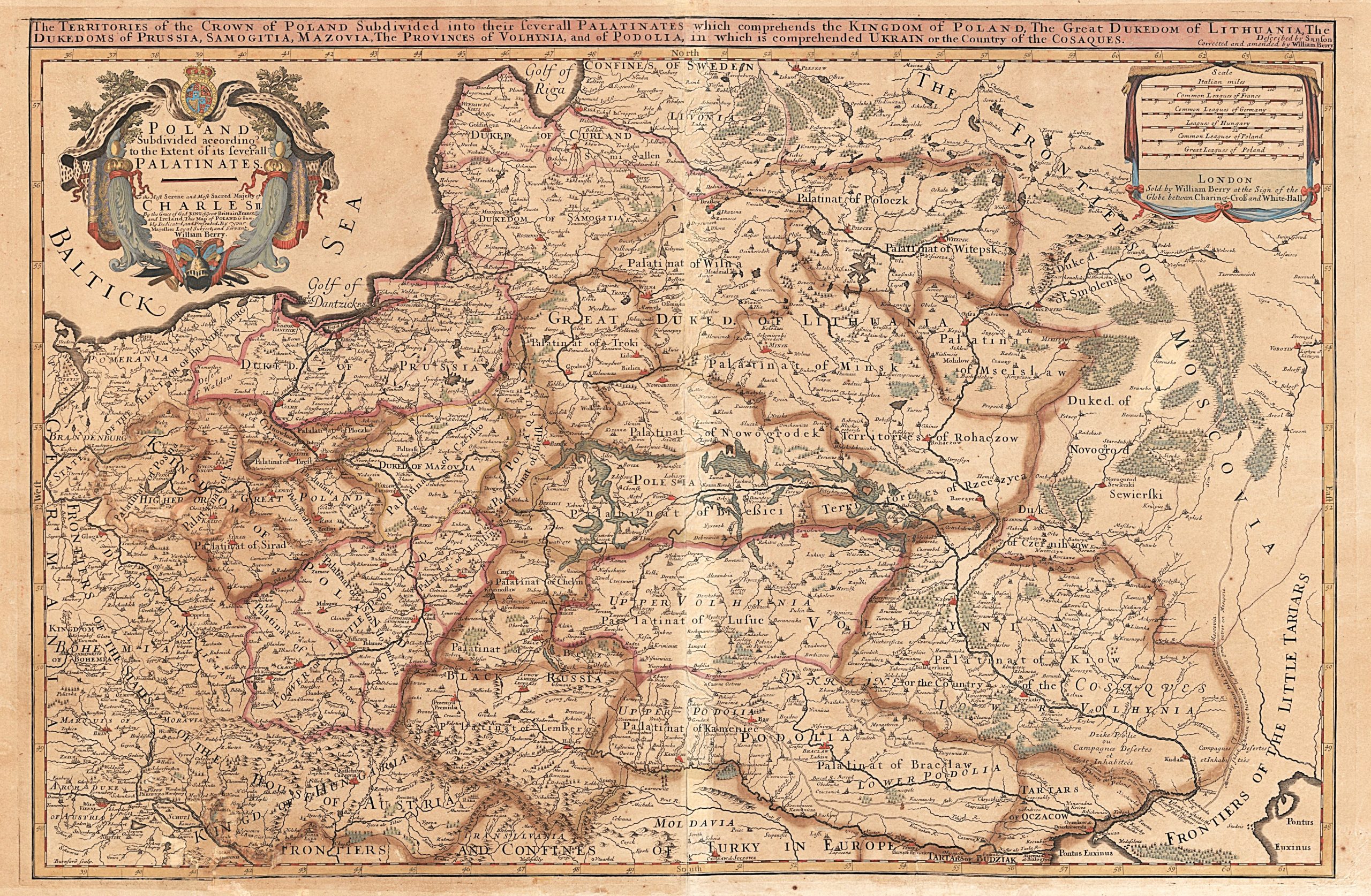
1683 W. Berry „Poland Subdivided According to the Extent of its Severall Palatinates…” 1
William Berry (1639–1718)
Guillaume Sanson (1633-1703)
Alexis Hubert Jaillot (1632-1712)
ATR žemėlapis 1683 m.
Londonas
53 x 86 cm.
ID: 2901
Kategorija: 1680-1700 > Abiejų Tautų Respublika > Berry, William > Dideli > Didžioji Britanija > Jaillot, Alexis Hubert > Labai reti ATR žemėlapiai > Mortier, Pierre > Sanson, Guillaume
„The Territories of the Crown of Poland subdivided into their Severall Palatinates which comprehends the Kingdom of Poland, The Great Dukedom of Lithuania, The Dukedoms of Prussia, Samogitia, Mazovia, The Provinces of Volhynia, and of Podolia in which is comprehended Ukrain or the Country of the Cosaques” Described by sanson Corrected and amended by William Berry
„Poland Subdivided According to the Extent of its Severall Palatinates / To the Most Serene and Most Sacred Majesty of CHARLES II by the Grace of God KING of Great Brttain France Ireland , This Map mof POLAND is hum bly Dedicated , and Presented By your Majesties Loyal Subject and Servant / William Berry
Guillaume Sanson, Alexis Hubert Jaillot, William Berry žemėlapių perdirbinys, išleistas Londone.
Pirmoji William Berry žemėlapio laida yra didžiausias Anglijoje Lenkijos / Lietuvos iki tol publikuotas ATR žemėlapis.
Tai yra ypač retas žemėlapis
K26/1
You may also like…
-
![]()
1744 J. Bowles „Poland Subdivided According to the Extent of its Severall Palatinates…”
John Bowles (1701-1779) William Berry...
-
![]()
1681 G. Sanson „Estats de la couronne de Pologne…”
Guillaume Sanson (1633-1703) Nicolas Sanson...
-
![]()
1675 G. Sanson „Estats de la couronne de Pologne…”
Guillaume Sanson (1633-1703) Nicolas Sanson...
-
![]()
1810 G. Sanson „Royaume de Pologne subdivisés suiuant l’estendu de ses etats…”
Guillaume Sanson (1633-1703) Nicolas Sanson...
-
![]()
1696 P. Mortier „Estats de la couronne de Pologne…” 2
Pierre ( Pieter) Mortier (1661-1711)...
-
![]()
1692 P. Mortier „Estats de la couronne de Pologne…” 1
Pierre ( Pieter) Mortier (1661-1711)...
-
![]()
1711 P. Mortier „Estats de la couronne de Pologne…” 5
Pierre ( Pieter) Mortier (1661-1711)...


